Tuesday, May 27, 2014

Roadside Yucca

So I ask, what better thing to do than blog about Yucca when holed up in a restroom for the night? That's right, folks, comin' to you live from the commode at the Harmony Hall Historic Plantation Site!

I was granted permission to camp on the grounds by Albert and upon my arrival I couldn't have been more pleased with plenty of green grass to pop my tent upon and a picnic table for relaxing...as well as this little restroom hut with running water for visitors. However, just as I had gotten into my tent for the evening, flashes of lightning illuminated the grounds and booming thunder rolled across the sky...I prepared for rain by zipping up my tent...but oh, no, nothing could have prepared me for what came next.

A wind like I have never heard before swept up from the river and farmfields behind me, carrying leaves and debris along with it - I wondered for a good second what on earth I was hearing - and then as the wind came crashing against my tentwalls, I knew. Instinctively, I grabbed for the main supporting pole and held it upright with all my might as I watched the rain and treetops blow furiously sideways. Next thing I knew, most all of my tentstakes had come loose and as I struggled to get them back into the ground I watched as a lake formed beneath me.

There was just one thing to do - abandon ship.

And so in the bathroom I will be for the night - it's warm and free of leaks - really not a bad deal. When it comes down to it, hiking teaches you to be grateful for what you have rather than focusing on what you don't have.

Thank you, Albert! I'm sure if you knew the state I was in, you'd make arrangements for even better accommodations!

So, about that Yucca! The last few days, I have had the pleasure of stumbling upon this plant roadside on those long stretches of "nowhere." Most often I found it growing by an old homesite or hugging the telephone poles. I have also seen it standing one lonesome plant atop sandy roadside hills. The nice thing about Yucca is that it is a plant that maintains it's edible parts high above the ground and therefore less likely to be covered in the grit and run-off from the road unlike most roadside plants (although I wouldn't munch those by the telephone poles due to whatever the wood may be treated with). It's also easy to spot from afar.

Yucca filamentosa - a member of the Lily Family (Liliaceae)
Yucca is woody at its base with long, thick, evergreen leaves that form a dense basal rosette. Leaves are sword-like, growing erect 1- 2 1/2 ' long with parallel veins. Flowers are large and showy, six-petaled, white, waxy to the touch, and grow on a central branching stalk.

Yucca filamentosa's 6 - petaled white petals


Yucca filamentosa, the species that I have seen most frequently on the MST is also known as Bear-Grass. It can reach a height of 5 feet and will have flowers loosely arranged on a stalk. Leaves will have peeling threads or fibers that will often curl away from the leaf margins.


Besides merely munching on the raw petals of Yucca, they can be thrown into a simple hiker salad...

1 large handful or bowl of salad greens
1 ripe mango
2 Yucca flowers
squeeze of lemon or lime
 
As a hiker, it is best to purchase salad greens from the store in a single-serving bag or bowl that you know you can use up in  just a meal or two.
Slice mango into thin slices. Pluck petals from flower base. Add to greens along with your squeeze of lemon or lime and toss to blend.
 
(recipe from: A Guide to the Edible and Medicinal Plants of the Mountains to Sea Trail)
 
Another fruit that you could easily add to your Yucca salad would be fresh blueberries.

 
Bluberries (Vaccinium spp.)
 

I had the pleasure of walking through 2 miles of blueberry farms today. Let me tell you...this is how you make a hiker's day. I could barely make my way down the trail as I had to just stop for a bite with every ripe cluster I saw. Thank you Big Sky Blueberries and Burney's Blueberries! It was certainly a treat.

Blueberries ripening at local farms just outside of White Lake, NC

I will tell you the easiest way to recognize a Blueberry...look for the crown at it's end and often, though not always, a whitish bloom on the berry. Blueberry is such an amazing plant in more ways than just its fruit that I will save further details for a blog all its own.

Before I go, I'd like to say a big thank you to Mickee at the Melwood Hotel. This lovely lady was more than helpful in making sure that I had a pleasant stay by not only giving me a lakeside room, but upon my sadness at hearing they did not have beer at the convenience store down the street, offered to go grab me one from a place further down the street and bring it back to me when she got off work. Not only did she later arrive with frosty beer in hand, but powerades for the next morning, gummi bears, and a bag of potato chips (all of which has already been consumed). It's truly awesome the kind people you meet out here!


Monday, May 26, 2014

From Nowhere to Somewhere

One of the many overgrown and dilapidated houses along Canetuck Rd

This was the kind of house that predominated my miles of walking the last couple of days...that is if I saw a house at all. For the most part it was thick pine woods of Loblolly and Long Leaf as well as Oak with the occasional mailbox I could see a mile ahead peeking out from the between the boughs. Once upon the mailbox, I'd see some suggestion of a driveway, really just a forest path, back to what I could only assume was a house. On numerous occasions, I knew for certain there was a house hidden away as 2, 3, 4, dogs would come barreling around the corner just after I passed the drive, barking and snarling to let me know to keep to my road. However, upon my turning around, the apparently odd looking creature I am with a hump back, big black bug-like eyes, and four-legged, the front two being spider-like, they usually retreated, of course turning and barking the whole way home.

These 40 miles of seemingly nowhere began after leaving Moore's Creek Battlefield where I spent the night with the ghosts of the Revolutionary War. No, no actual ghosts, but it was kinda neat to think about their being there. Leaving here I soon crossed the Black River...which while at the Battlefield I learned the reason for not only this river's color, but seemingly all the creeks and streams in the area. Tannins from the trees - yup filling a Nalgene full of this stuff is like drinking Tree Tea, folks!

The Black River

After crossing this river, it wasn't long before I came to Canetuck Road. I don't know what town I was in here...but I think somethin' cane tuck it...because it was the middle of nowhere. You know I thought I'd already been in the middle of nowhere. Nope. This was the middle of nowhere.

To my thrill, I thought I had come to a convenience store at the end of Canetuck Rd. where it changes names to Natmore Rd., but upon closer inspection saw that it had been reduced a storage shed for cobweb-covered junk...a hoarder's dream. It was all locked up with a note stuck on the door, yellowed with age that read I would like to buy most of the things in your store, please call me. I tried to sit down on an old metal lawn chair outside for a snack...but as soon as I got the wrapper off my granola bar, a dog chased me out of here too.

Not to fret, I would soon come to the little town of Kelly...they reportedly had a convenience store!

Along the way, I met this little guy...

The smallest lil turtle I have ever seen...I helped him gently off the road as I have seen too many of his kind smooshed on the asphault.

As soon as I strolled into town, a small truck pulled over...it was none other than Richard, the man that had given me permission to camp at the Kelly Museum! Perfect timing. He began to introduce himself, and I was oh so happy to see him, knowing that I'd have a place secured for the night, but he could see my eyes wandering beyond him to the Kelly convenience store on the corner ahead. Finally I exclaimed, "Oh I've just sooo been looking forward to an ice cold cola the last 18 miles, do you mind if I just run up there?!"

"Oh, why, they are closed on Sunday!"

SO much for that. It doesn't take much to crush a tired hiker's hopes. But Richard quickly turned my night around, but granting me a night inside the museum. Here I had not only a kitchen and bathroom at my disposal but all the reading material and interesting exhibits I could want for entertainment. They even had a whole ol' fashioned writing room on display...thank goodness I don't have to lug this in my backpack...

The writer's companion from another era at the Kelly Museum in Kelly, NC

Thank you Richard for the wonderful accommodations!!

Leaving Kelly it was another 18 miles to the nearest town of White Lake. As I walked Rt 53, again bordered by only Pine and Oak and believe it or not, less houses than before, now only gameland, I had numerous motorists stop and offer me a ride...who seemed mighty perplexed when I turned them down. They drove away reluctantly, only confirming my suspicions that it would be a long time until I was indeed somewhere.

And suddenly I was somewhere...the Carolina Bays!!


Veering off Rt. 53, I finally got my feet back on trail, weaving by way through the Bay and Pine woods of Singletary State Park, home to Singletary Lake. I didn't see a single soul and so it was just me and this beautiful forest, through which I eventually hiked out to this lovely pier leading me out onto the lake. Walking down the pier, I marveled at the Pond Cypress (Taxodium distichum var. imbricarium) growing, their roots deep in the water, fragrant and adorned with hanging Spanish Moss (actually a lichen). An interesting note...experts really do not have a definite theory as to how these bays were formed. One theory is that they are the result of a spray of meteorites or the impact of a large comet. Another is that they are the result of simple upwellings of groundwater. I do like the exploding comet theory best. All in all, I decided a  swim in this giant comet puddle was definitely in order.

Check out those sweet hiker tan lines!


Eventually, my trail turned into wide sandy forest road walk as I made my way in Bladen State Forest...


The sand here at the bays is incredibly white and provides not only a home to the Scrub Oak and Pine, but to wildlife such as this Black Bear...

black bear print - one of many in the sandy trail in Bladen State Forest

After my swim and tracking the Black Bear it was another couple of miles into the town of White Lake...I expected a campground, maybe a convenience store...

The attractions of White Lake, NC

Oh White Lake has a convenience store, as well as a campground that spans 3/4 mile one direction and probably as far in another...and pizza and ice cream and lattes and well...even mini golf! Just a wee intense to this hiker who's been in the gen-u-ine middle of nowhere for the last two days...but also quite wonderful when it comes to that new addiction to ice cold cola...and I have this view from my the backdoor of my quaint motel room...

View from my lakeside room at the Melwood Motel
Stay tuned to for the next blog...with a showcase on Yucca!

Saturday, May 24, 2014

Feed me Seymour!

 
 Venus Fly Trap (Dionaea muscipula)
This mouthy lil friend was the crowning glory of my day spent in Holly Shelter Gamelands. Oh, yes...there was some misadventure yet again which I'll get to in a bit, but this plant really needs to take the spotlight!

I had been told by numerous locals that I could expect to find Venus Flytraps here on this 80,000 acre preserve. Therefore, I was on the hunt. However, considering that they are such small plants, the traps being just a half-inch across in length and sitting close to the ground, I figured I' d have to do some searching. I began the day early, hiking at an easy pace and walking close to the edge of the road, my eyes never leaving the grass. Yet I saw not a one. What I did see within just a mile of crossing into the gamelands were large clusters of Pitcher Plants. Not only the Green Pitcher Plant (Sarrancenia oreophila), but also the Purple Pitcher Plant (Sarrancenia purpurea). So much for seeing just one on the trail thus far. These regal-looking plants persisted throughout most of the day's hike.

Clusters of various Pitcher Plants (Sarracenia spp.) along forest roads inside the Holly Gamelands

the pitchers of the Purple Pitcher Plant (Sarracenia purpurea)


After about 3 miles, I still hadn't come across a single Venus Fly Trap, so I left the edge of the trail and simply started cruising. At one point I passed a large cluster of Pitcher Plants growing in high grass by a swampy drainage ditch. Perhaps I'll just take a look over here...

I took some more pics of the Pitcher Plants as well as this other species of Grass-Pink...

Pale Grass-Pink Orchid (Calopogon pallidus)
And then noticed a small 5-petaled white flower I'd never seen before...

The 5-petaled white flowers of the Venus Fly Trap (Dionaea muscipula). These sat clustered at the top of 6-8" erect stems.

I got up close for a photo and that was when I noticed its basal leaves. Tiny sharp-toothed red and green mouths ready to devour whatever insect may cross their path.


The basal leaves of the Venus Fly Trap (Dionaea muscipula)

These traps capture and digest mostly small crawling bugs such as spiders, ants, beetles, oh and the hopping ones as well, like grasshoppers. Occasionally they will catch a low-to-the-ground flying insect. The hair-like teeth would more accurately be called cilia. These can sense when a prey is worth it's energy digesting. If the prey is too small it will simply crawl out. If the prey is a hardy meal it will inevitably brush another hair or two and the trap will suddenly close SHUT. Over the course of about 12 days, the prey will all but be completely digested, leaving just a husk of bug.

The Venus Fly Trap is North Carolina's state plant and is native to only a small portion of the North Carolina coast and South Carolina. In regard to North Carolina, it is reportedly found only within a 60 mile radius of Wilmington. Sadly, it is considered a highly endangered plant, with some conservancy groups stating inevitable extinction in the wild. It is endangered due to habitat loss and fire suppression, as well as people harvesting them for an exotic sell.

Holly Shelter Gamelands returning to wetland

I also learned after hiking through this area that this is one of the areas that burned so intensely while I was hiking in 2011. I don't know if my readers remember my walking for days in thick smoke...apparently this was part of the cause. However, this special preserve having once been largely a wetland and then converted to rows and rows of Long Leaf Pine by the paper mill that once owned the property, is now on it's way to returning to its natural state. The Long Leaf Pine is still thriving as is the wetlands. I passed this area on my way out...and oh was I ever glad to get outta here!

One of the forest roads, bordered by Long Leaf Pine (Pinus palustris) traveling through Holly Shelter Gameland

It must have been all my searching for those Venus Fly Traps that led me to take a wrong turn. I had specifically been warned by Monique Baker, tourism director for Pender County "Don't get yourself turned around in there! And whatever you do, don't go down any of the lesser side roads" as well as by Todd Rademacher, the planning director for the town of Surf City, "Make sure you don't get lost, they'll never find you in there!" Well...yeah...I got lost.

This 80,000 acre preserve, yes 80,000 acres...well 100,000 acres if you include the Angola Bay Preserve which connects to it, is accessed by one main road, criss-crossed by one other major road and then there are the host of lesser roads. The ones Monique warned me not to go down...the ones the MST directs me down. Upon realizing I was lost, sometime during the blazingly hot early afternoon. I checked my maps - no road names. I checked my directions - no help there. I called Kate Dixon- she offered to see if one of the maingates was open and to come get me - oh no this hiker ain't goin' out like that. She had no computer access to look at a more detailed map. Kate called Monique...no computer access. Kate called my boyfriend...no computer access. Yes, folks, in today's modern tech era! Kate called Joellen - Outreach Coordinator for the FMST - Joellen had computer access.

Joellen proceeded to spend an hour on the phone with me trying to pinpoint exactly where I was. "Did the road squiggle before this intersection?" "Do you remember any distinguishing signs?" "Do you remember walking beside a creek?" "Were there any gates." It was like a mobile game of Where's Waldo. The conversation ended with Joellen saying over the crackly line, "Okay, so I think you are at this intersection, which means you should be able to walk 2 miles down this lesser road and arrive back at the intersection you should have come to...but there's a possibility you aren't here in which case you'll have to turn around and walk back and call me again." I had one blinking bar of battery left. I hoisted my backpack and started down one of those ominous lesser roads...

And came to the right intersection!!! Joellen you are one helluva navigator!


Just so y'all know...I am acting as the guinnea pig for this new route. After I'm all done getting lost and turned back around, the FMST will know where all of the kinks are and get them ironed out in the updated directions. Pete Wetzel, you've done an excellent job, especially considering how many miles I've walked and how, relatively, little I've gotten lost!


The the heart-shaped upper leaf of a Green Pitcher Plant


I'd like to end this blog with a giant THANK YOU to Monique Baker, who took me in for two nights in Pender County, shared with me delicious food and drink, and whose cats, Daisy, Squeak, and Leo thoroughly kept me entertained. I had so much fun Monique -true southern hospitality! Thank you as well to Todd Rachemacher who went out of his way to pick me up from the trail, take me to a lovely campground in Surf City called Lanier's, and drop me back off bright and early! Thank you to Kate Dixon for also shuttling me to and from the trail, linking me up with so many wonderful people, and for meeting me at the trailhead with that ice cold coke at the end of my long, hard, and lost day in Holly Shelter Gamelands! And lastly thank you to some generous businesses in the area that provided excellent food and drink, as well as conversation, and allowed me to treat their space as my personal office for several hours- specifically Dabby's Grill at intersection of US 117 and Camp Kirkwood Road, and Harvey's Tavern and Deli in downtown Burgaw!

Tuesday, May 20, 2014

Rare Specimans - both Plant and Human


The last five days have been a whirlwind! I've hiked just shy of 100 miles, weaving in and out of the Croatan National Forest on forest roads, walking long stretches of rural countryside, sharing the "trail" with Mack trucks on major highways, dodging cars in Walmart parking lots, Lowes parking lots, and Food Lion parking lots, accidentally sneaking onto Camp Lejeune Marine base, and have now returned to the beach here on Topsail Island!

I have begun the new route through the Coastal Plain...150 miles of rugged jungle-like wilderness contrasted, and sometimes very much complimented, with the constructs of modern civilization.

A sandy forest road through the Croatan National Forest
So one of the challenges of taking the reroute is not yet knowing where all of the services are or even where I'll be crossing a stream or a spring. None of this information has been documented in the directions that I'm following. So as I headed out from my motel the other morning in Havelock, feeling refreshed and ready to take on the world, I came to a gas station and knew that this may be my last water source before I headed in the Croatan following a maze of forest roads. However, remembering what it felt like to lug 4 liters of water down the Neusiok Trail and how I probably sweat out twice as much water as a result, I figured 2.5 liters would do it. Anyway, my directions did mention a ford, so I figured if I had to, I could get water from here.

As I made my way down not only the unimproved but unmarked forest roads, I marveled at the towering Long Leaf Pines to either side of me as well as their blackened bases. Long Leaf Pine Savannahs require periodic burnings in order for the species to thrive as well as for the health of the whole ecosystem. I could see this forest was doing well with these lil guys at my feet...

Me and a lil' Long Leaf Pine (Pinus palustris) - it was so cute, I just had to get a selfie with it


The carnivorous plants abounded as well, more of the tiny soil micro-organism loving Bladderwort as well as this find! This is the first I have seen in the wild and the only one I've seen on the trail since...I found it growing in a muddy tire track...

Green Pitcher Plant (Sarrancenia oreophila) - according to Wiki, this species is the most endangered of all the Pitcher Plants (Sarrancenia spp.) and it's range is limited to a handful of sites in Alabama, Georgia, and North Carolina.

This is the rolled leaf of the Green Pitcher Plant which creates a tube. At it's bottom is a pool of digestive juices. Lining it's waxy sides are downward pointing hairs. The little insect I found in here (that black dot) stood little chance of surviving.

Backside of the Green Pitcher Plant's 5-petaled flower.

The day went on and the trail vascillated between easy gravel road walking and wide tracks of ankle-deep soft white sand. The day grew hotter and without a drop of water in sight. I did eventually ford that stream, but when I filled up my Nalgene, the water was literally the color of sweet tea. Therefore, I soon began to comb the woods for a place to stay for the night, thinking at least if I stopped moving I could conserve my water and then feel better to hike further in the morning. But the woods were either thick with shrubs and dense tuffs of coarse grass or blackened with soot. I stumbled upon a groundwater monitoring station with the most beautiful grassy lawn surrounding it...however also surrounding it was a barbwire fence and a sign that read "Tampering with this facility is a federal offense- report any suspicious activity to local police or 911" I thought, eh, probably not the best place...but I was very, very, tempted.

Blackened bases of burned Long-Leaf Pines


As evening approached I stumbled upon a sandy track that clearly had been used by vehicles at some point, but a sign now stood there stating, "No Motorized Vehicles Permitted." Good enough for me. I walked some ways back, where it forked, chose the lesser used track and set up camp. The wind began to pick up and the sky just above the waving tops of the Long Leaf Pines darkened. I actually hoped for rain. At least if it rained, I could get some water!

Although the winds stayed strong, the rain did not come. However, exhausted as I was, despite the thrashing walls of my tent, I soon drifted off to sleep. Next thing I knew I awoke with a start to the sound of a motor coming up fast behind me. I shot straight up and struggled to get the zipper open to my tent. As I did, and I fumbled to try and climb out, I saw a four-wheeler bearing a large headlight come barreling down the trail where, "no motorized vehicles were permitted." Then in front of me pulled in a pick-up truck and a little red sports car. Glad I had not been run over, now I was simply  frustrated that sleep would not be occurring. Luckily, after the four-wheeler conferred with the other two vehicles, they soon revved their engines and sped away. And so although shaken, I eventually fell back asleep, the wind still whipping.

Sometime in the early morning hours I awoke to the sound of thrumming rain against my tent walls and nylon in my face. The wind had collapsed my tent upon me and it was a torrential downpour. More scurrying ensued as I struggled to get my tent back up in the wind, I felt a like a sailor in a storm struggling with his mast. I soon did get it standing, the stakes shoved as best as I could in the wet sand, but not quick enough to have prevented giant pools of water from gather inside my tent. I clung to my foam sleeping pad like a life raft ...and put a pot out to collect some water.

By the time the storm ended, over 2 hours later, I had 12 oz of water to add to my remaining 8 oz and it was time to get the hell outta there! I shoved my sopping wet tent, sleeping bag, and clothes, into my bag and got to hiking as fast as I could towards paved roads and hopefully water...within 3 miles I reached this horse farm!

The hose hooked up to fill the horse trough...hey, good 'nuff for them, good 'nuff for me - afterwards I saw some workers peering at me from the roof looking rather perplexed at the girl collapsed against the fence chugging water


And then a gas station 1 mile later...ah well.

However, no matter how hard this day was...I knew I was hiking toward some trail magic...Wilbur and Jane.

Wilbur and Jane Gurgunas - trail angels - notice that big NCMST decal on the side of their truck!


I got linked up with these lovely people through Kate Dixon. They are dedicated FMST members as well as volunteers with the Mount Rogers AT Crew. Wilbur and Jane, you are a couple of the kindest folks I have ever met. They fed me, gave me an amazing bed stacked with pillows to sleep upon, assisted me in slack-packing for 2 days, and helped me decipher my directions in the evenings. And, I got to eat all the fresh pecans I wanted. Wilbur and Jane have farmed the land ever since they were little ones and amongst other crops such as corn, wheat, watermelon, and various veggies, are Pecan trees. I've never had pecans that tasted that good. Thank you so much Wilbur and Jane for all that you did and do! You are incredible people.

I'd also like to give a shout out to a woman I met at Camp Lejeune - you know who you are- that helped me immensely. So yeah, I've definitely gotten lost a couple of times in the last few days...it has begun...and on my first occasion I managed to take a sidewalk right past the guys with big guns in full military gear and past the maingate security at Camp Lejeune, . Upon their seeing me I just gave them a friendly nod and strode on by. They watched me, but never stopped me, so I thought, Okay, I must be good, rails to trails pathway here I come! But when the sidewalk petered out after a couple of miles, I soon realized I had taken a wrong turn. After hemming and hawing for sometime about what to do I ran into a woman who upon hearing what had happened exclaimed, "They just let you walk onto base? You have no military ID?"

"Nope." I answered.

After she tried to explain to me how to get back to my trail and seeing the blank look on my face, she offered to simply give me a ride...and added, "You know this is probably best anyway, if they catch you on here without ID, they're liable to hold you for questioning."

Now that would have been a story for the blog!


View from the bridge that led me from the mainland to Topsail

And now with all the restricted military areas finally behind me, I have passed onto Topsail Island...again returning to the beach. These waters are crystal clear and the sand fine and compact, easy for the walking. Not as many shells washed ashore as on the Outer Banks, but when the tide comes in, it forms little pools and rivulets that seem to have little habitats all their own as the birds crowd around them. Such beauty to be had and when you're moving at my pace...you get to just take it all in...

Close-up view of crystal clear water in a skinny stream on shore


Wednesday, May 14, 2014

The Neusiok Trail


Oh Neusiok Trail, quite the trail you were! For about 14 miles the MST follows the Neusiok Trail. This trail travels through a Long-Leaf Pine Savannah and is breath-takingly beautiful as well as pain-stakingly difficult given it's environmental factors such as horrific amounts of bugs, lots of mud, and lots of sun. But back to the beautiful, before I give you some more details of the not-so-pleasant parts. You see, the thing I've learned about the Neusiok is that it is ever changing...

Beginning portion of the Neusiok Trail
 The picture you see above was taken within the first few miles, however the trail often returned to this kind of environment. A grassy surface thick with White Clover, along with so many wildflowers unique to this portion of the MST as well as familiar trees that I had yet to see on this trip that I could barely get my hike on because of all my picture taking. On this lil stretch, a frolicking river otter just about ran into me as he made his way down the trail and immediately following that, I startled some enormous bird with a wing-span of a good 5-feet, perhaps a hawk or an owl, I do not know. I felt like I had entered some land before time.

However, somewhere after mile 8, the mud began. I have no pictures of this. I didn't care to take a single damn picture of that mud or myself sinking in it. I'm talking black as night, thick as molasses, shoe-sucking, hiking-stick stealing mud. I traveled and periodically cursed my way through this for a good couple of miles. I wondered how I ever did hiking like this on the AT for states at a time. No matter my fashionable new Brooks Ravenna hiking sneakers and Smartwool PhD socks, just black clumps of mud down there for feet and splattered all the way up the backs of my thighs.


I was then flung from the mud on to this forest road. Oh sweet baby Jesus (to use a southernism), it was better than the mud, but this portion had the sun and a road that appeared to go into infinity. I poured sweat, at least cleaning some of the mud from my skin while the sun helped to bake and flake off the mud on my shoes. The wildflowers and river otter were a distant memory.

One of the many boardwalks on the Neusiok Trail
After a little over two miles on that road...these came to my rescue...oh sweet boardwalks! These are frequent on the trail and I knew they were bound to appear in frequency sooner. There had been a couple early on, but then all but non-existent. Again, I was a happy hiker, able to take in the plant life and cruise my way into camp at Dogwood Shelter - a lean to with ample tent space so that this hiker could escape the bugs. The last time I had been through here, just to give you a reminder, this is how I camped at Copperhead Landing Shelter...

My non-free-standing tent, rigged up with ropes found in the shelter - I pulled this off sometime around 2 am, after various other techniques failed to keep the mosquitoes at bay.

So now well rested and enjoying a room here in Havelock...let me give you a lil' slideshow of the plant faces of the Neusiok Trail...

Grass-Pink (Calopogon), a member of the Orchid family. I am not certain what species I have here, but I believe it to be either C.pulchellus or C.barbatus. Calopogon means "beautiful beard" referring to the scruffy yellow cluster of hairs. These hairs are there to attract pollinators, but an insect gets a surprise when the flower snaps shut on him, and he has to crawl his way out, in turn pollinating the reproductive parts in the process.
Orange Milkwort (Polygala lutea), a member of the Milkwort Family. These enjoyed the bright sun along the edges of grassy trail. 
Flowers of Inflated Bladderwort (Utricularia inflate)
 
Inflated stalks of Inflated Bladderwort, acting as a float. Leaves are beneath water. Bladderworts are actually carnivorous plants and to refer to their parts as leaves and roots and stalks in the typical sense is actually not entirely accurate. The reason for their name refers to their specialized "bladder" like parts that acts as a trap for underwater such as mosquito larvae and water fleas. When the insect brushes up against tiny hairs, it triggers this bladder which opens and sucks in the nearby prey along with the water it's in.

Another Bladderwort - I had some trouble figuring exactly which species this was as Newcombs only lists so many and the identifying features seem to come down to width of its lower lip. It seems to me this is Flat-leaved Bladderwort (U. intermedia). What's unique about this Bladderwort is that it grew in the soil from just one thread of a stem, none of it's "leaves" visible. Turns out this plants feeds off of protozoa that swim in water-saturated soil. Makes sense, considering I found this little yellow face in the black wet soil along one of the boardwalks. I spotted only a handful few of these on the trail!


And lastly the cone of Long Leaf Pine (Pinus palustris). See my blog post http://www.thebotanicalhiker.blogspot.com/2011/07/long-leaf-pine-pinus-palustris.html
for more information about how to make a medicinal tea and it's properties!


Monday, May 12, 2014

Trail Magic in the Marsh

 
I am presently writing to you from the comforts of a lil gas station along Rt. 101, happily awaiting a veggie pizza...what a fabulously beautiful last few days it has been!

Last I wrote to you I was on the island of Ocracoke where I took a day off to enjoy the village. Here I stayed at Teeter's Campground - just a small family owned place - and Bubbie Boos was so kind as to give me the best price on the island (not easy to find a cheap place to stay). Thank you Bubbie Boos! The best part of staying at the campground, besides its short walk to nearby restaurants and hang-out spots such as Thai Moon, Live Oak Coffee, and the Ocracoke Coffee Company, was this feline friend Bumper, the campground cat, whom shared dinner with me at the picnic table and whom I woke up to outside my tent in the morning...

Bumper the cat - this lady earned her name because she was rescued as a kitten by the owner's daughter when she fell off the back of a truck passing through town. Fed by bottle and lots of love, she now calls Teeter's Campground home.
In the morning, as I left town I headed to Live Oak Coffee where I met Katy, the barista who shared some coffee with me on the front porch and sent me on my way with a gift of ginger tangerine tea. Awesome place with a laid-back vibe, local coffee, and friendly staff.

Live Oak Coffee - located in Ocracoke Village - be sure to stop in and say hi to Katy!
I then boarded the ferry for a long 2 1/2 hr tour over the Palmico Sound and over to Cedar Island - although called an island, it is still considered the mainland. Once up in the lounge area I had the pleasure of meeting some great people: Gwyn and Vernon Anderson, Lynn and John Powell, and Richard from Fort Lauderdale. There was no need to even pull out a book, as we chatted the entire time, with many a trail story and stories of friends and family. It was a pleasure to share that lil lounge with you and thank you for the donation (its feeding me right now!)


Once on Cedar Island, a long marsh walk ensued...miles and miles of nothing but a long flat road bordered by green grass and wildflowers such as Red and White Clovers, English Plantain, Fleabane, and False Garlic, which ran between two long channels of fast-flowing brown water, and marsh grasses as far as the eye could see on both sides. No shade and lots of wind, so much that I sometimes found myself being thrown this way and that. However, with only the occasional car, there wasn't anyone to really notice my seemingly inebriated stroll.


That tree you see was the ONLY tree and shade on the entire road- you bet I took a short break there! 

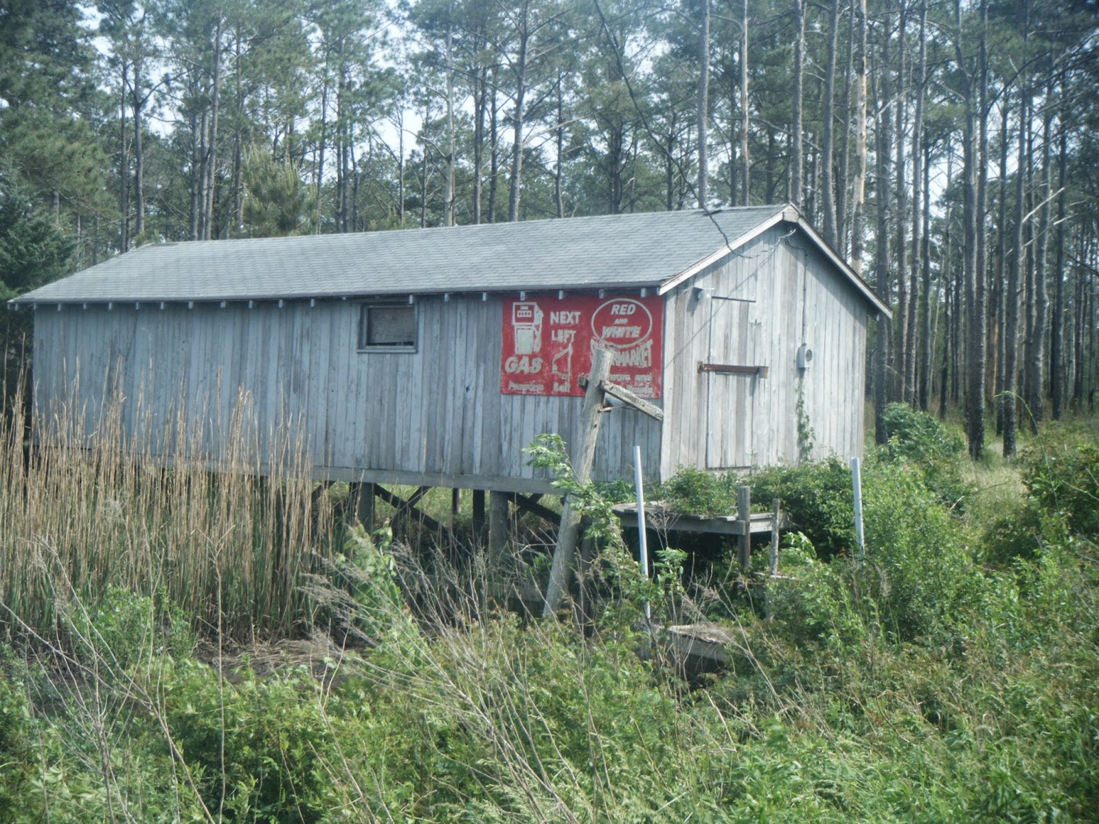
Greeted by this old shack, I knew I wasn't far from my destination for the night, so with finally a place to sit that wasn't in the tall grass it seemed a perfect place for a break...check out that ol' skool metal billboard on the side!


But far, far better than the shack was where I'd be staying that night...I was headed to an old friend of mine from the last time I hiked the MST, a woman and her husband that had kindly taken me in for the night, Diane and Stevie Styron.

Stevie, Diane, and Me


Here, I was immediately invited in and offered a cold glass of homemade iced tea with a touch of ginger and nutmeg and a seat on the couch...in the air conditioning mind you! Then it was lots of laughter through the night and catching up on the last few years. I even found out Diane has some family in the very town I've been living in in NY (and no one knows where that town is!) In the morning, Diane and I were called by Stevie to come outside if we wanted to get a look at somethin' cool. All of us being as quiet as could be made our way down the path that goes through the woods in their backyard to wide open plains of marsh grass and a deep ditch with shallow water that ran, again, for miles in either direction. There in the ditch we had a visitor of the alligator kind...about 6 feet long.


After that excitement it was a tour of the backwoods and of Diane's veggie garden, while also taking a look at all the wild edibles growing on the front lawn such as Wild Onion, Dandelion, and Pennywort. Sometime the night before I had mentioned going to a couple's house that was listed in the guidebook as a friendly place to camp...turned out it was Diane's mother's house! Considering this, Diane suggested that a slackpack may be in order. Awesome. I got to do 11 miles without a pack and a whole day to simply take my time.

I ended up spending the night in Arlene and John Wood's house and made to feel like one of the family. I met Diane's brother, Kelly and her uncle, Bobby. Veggie burgers and macaroni salad and good conversation went on until late and we had to hit the hay. I also got a tour of her backyard with it's herbs and blueberries and kale and onions, with the sweet smell of Honeysuckle permeated the air.

Thank you so much, Diane and family!!! You are truly a gift to the trail.

To finish up this blog, I'd like to feature just a few more faces of trail magic...they are of the animal variety, but they deserve to be featured nonetheless because they put a smile on my face, well almost all of them...

I met this beauty not long after getting off the Cedar Island Ferry. She was with four others in a pasture right on the main road. After some good pets on the nose, she insisted on following me down the trail as long as her fencing would allow her.

This guy who sat on the edge of the road through the marshland ( I moved him a lil closer to the water) was unfortunately a bit camera-shy
These butterflies were abundant on the grassy trail headed towards Frisco Campground (still on the Outer Banks) They fluttered and flittered up and down the trail. Here, this one sits on Bull Thistle.
Jacob the Cat enjoying a good rub on the trekking poles at Davis Provisions- a super hiker-friendly store along the MST in the tiny town of Davis

And lastly, this is the one that didn't bring a smile to my face - luckily my trekking poles found him before I did while hiking feverishly down the sandy trail just before Frisco Campground (also on the Outer Banks) But I do believe he's still a bit of trail magic - awesome to have seen him and to have stayed out of his way!
My friend, Pixie, told me in a text message on one of my first days out to, "find some magic out there!" I told her it was everywhere out here and that I was bound to find some...look Pixie, look, it is!