Wednesday, November 30, 2016

The Cedar Swamp at High Point State Park

Boardwalk through the Cedar Swamp - Atlantic White Cedar and Holly line its edge while Wild Calla grows in the mosses below
The Cedar Swamp Trail found within High Point State Park is a little known gem. Now please, do not let its name deter you as it did me. My love told me repeatedly what a special spot it was this past summer....but anything called a swamp in New Jersey I typically find less than appealing during the warm months. However, he kept on about it and I was looking for a new trail for my next plant walk. There's a lot of factors that can come into play when seeking a place to lead a guided hike - must be easy to moderate in difficulty, no more than a couple miles long, and of course...botanically diverse. So when I learned that the Cedar Swamp was more than a mere swamp but rather a glacial erratic filled bog with plants rarely found in these parts...and fit all the aforementioned criteria to boot...I gladly gave in.

The Cedar Swamp Trail is about 2 miles long and shaped like a lollipop, in other words, the hiker is not forced to go "out and back" but rather, walk the trail to a large loop so that your steps are only retraced at the end of the hike. It is level and well- marked and contains some of the first miles of the Shawangunk Ridge Trail (read: http://thebotanicalhiker.blogspot.com/2016/11/shawangunk-ridge-trail.html for more info). This is also an excellent time to hike the trail given that the entire park at High Point State Park is presently free of charge (no charge after Labor Day)

The history of this trail sets the botanical stage for a fascinating walk through time. The Cedar Swamp is better defined as a glacial bog. About 15,000 years a retreating glacier left in its wake a 30-acre pond. Life naturally began to form, firstly with lichen, then mosses, and eventually herbaceous and woody plants. As the vegetation sprouted, flourished, and died, decomposing matter gradually filled in the pond, creating a deeply layered bed of soft acidic soil and the bog we know today. More recently, well on a relative scale, about 300 years ago, a random Atlantic White Cedar (Chamaecyparis thyoides) seed, likely carried on the wings of a bird or traveling haplessly on a wind current from the Atlantic coast, landed here in the bog. It germinated, sprouted and eventually created the dense stand of Atlantic White Cedar that remains here today.

However the ecosystem continues to change here. The seeds of Eastern Hemlock, Birches and hardwood trees, which are what surround this bog, continued to be carried to this site by wildlife, wind, run-off water, and even our boot-clad feet. These trees do not require the same amount of sunlight to flourish and are more naturally suited to this mountaintop environment, therefore the sun-loving Cedars are gradually being crowded out. How incredible to walk through this  bog and see Eastern Hemlock (Tsuga canadensis), Black Birch (Betula lenta), and Atlantic White Cedar (Chamaecyparis thyoides) with boughs interlaced. The bog is also strewn with boulders rolled and tumbled like pebbles by the glacier thousands of years ago.

Winterberry - a Holly with smooth deciduous leaves (Ilex verticillata)
At the base of these trees and lichenized boulders are exposed roots, rotting downed trees, and a springy bed of bright green moss. This vegetation continues to fill in the bog and when we hiked through in early August after a rather dry summer, there was really no water in sight. However this acidic environment still plays host to a wealth of plant life. Tangled vines of Partridgeberry (Mitchella repens) wove throughout the forest floor as did tiny moisture-loving 3-leaved Blackberry (Rubus) vines, single Canada Mayflower (Maianthemum canadensis) leaves waved as we walked by, and Wintergreen (Gaultheria procumbens) berries tempted us like tiny red candies lining the trail. A few shriveled blueberries still clung to Highbush Blueberry (Vaccinium corymbosum) bushes and nearby deciduous, smooth-leaf, Holly (Ilex verticillata) bushes were lit up like the holidays to come.

Wild Calla (Calla palustris) - although technically edible, a whole lot of work to process. The root and berries of Wild Calla may be dried and pulverized, boiled, and dried, and perhaps boiled and dried some more to prevent the calcium oxalate crystals inherent in the fresh plant from doing harm. These crystals will cause your tongue and throat to feel as if it is being pierced by hundreds of needles...however native people did employ it as did the pioneers. It was in fact used as the flour in Missen (famine) bread.
Along the beautifully crafted boardwalk was where we spotted the most intriguing plant life. Wild Calla (Calla palustris) shown its shiny green soon-to-be scarlet spadixes, easily seen even amidst the scramble of mosses. Wild Calla is a plant often found in more northerly regions, further evidence that this habitat was once a colder one. Bunchberry (Cornus canadensis) with its wheel of elliptical egg-shaped leaves also graced the carpets of moss, alongside the fresh smelling needles of Black Spruce (Picea mariana), two more unlikely inhabitants in this now warmer clime.

Bunchberry (Cornus canadensis) - the smallest member of the Dogwood Family - develops edible berries in early autumn that can be somewhat tasteless but contain abundant pectin and therefore excellent for use in jam
We stopped to have a snack on a most inviting bench, one of a few that are located along the trail, and to admire the trail sign for the Shawangunk Trail that we would be hiking in a few weeks. We were no more than halfway through our granola bars when I finally got curious about the rustling that was growing ever louder just behind us down the trail. I turned just in time to meet the round eyes of a large black bear that suddenly appeared just as alarmed as me. I stood up with a jolt and a grabbed Scott to pull him near for a closer look, when the bear darted from the thicket of Rhododendron and Blueberry bushes as fast as he could and ran clumsily down the trail. I do believe, for once, a bear was more frightened of me than I was of him!

American Chestnut (Castanaea dentata) - the nuts at one time were the most delicious to be found in all the North American woods.
Another unique inhabitant of this trail included American Chestnut (Castanea dentata). American Chestnut does reside throughout the northern forests of New Jersey to many a hiker's surprise. They have not all been wiped out but simply can never reach full maturity, falling ill to a blight within their first few years and usually dying by 20 years old. However, common or not, upon seeing young seemingly healthy trees like this one here, they seem a slender but bright ray of hope. Perhaps, just maybe, this will be one to make it.

The inedible and toxic, although wonderfully lemony smelling, berries of Sassafras (Sassafras albidum)
I returned nearly a month later to lead a hike with the Sierra Club and my fellow hikers and plant enthusiasts seemed to fall in love with this place as much as I did. By this point the Wild Calla berries had turned scarlet and the Sassafras (Sassafras albidum) that lined the old road that makes up the beginning portion of this trail had gone to berry as well. The Wintergreen berries were all the more prevalent and those of the Holly still persisted. Chicken of the Woods (Laetiporus) was even making an appearance.

Chicken of the Woods (Laetiporus)- edible and very tasty when cooked. 
This is one of the things I love about an easy trail such as the Cedar Swamp Trail. The hiking is effortless, allowing one to simply soak up all the sights along the way. It is also readily accessible enough that it can be revisited again and again throughout the year, creating a perfect opportunity for getting to know a relatively small area well and observing what plants sprout, blossom, and go to seed throughout the seasons. This trail may have been a new one for me but one that I believe will someday become an old friend.


Tuesday, November 15, 2016

Shawangunk Ridge Trail

A handmade sign for the SRT
This post will be the first in a series throughout these upcoming months highlighting some of the beautiful trails that we have here in our region. I blogged very little about my personal adventures over the spring and summer largely because I was too busy frolicking in the forest...I mean who afterall wants to sit in front of a computer screen on a warm sunny day, even a writer? Therefore I hope that these stories of the trail lend themselves to your own inspiration and dreams as our days grow colder and shorter. The cold months are perfect for planning your next adventure!

The Shawangunk Ridge Trail (SRT) runs for 71 miles from High Point monument in High Point State Park to the Mohonk Preserve in New Paltz, New York. It is just the right length for a week-long thru-hike or an ambling series of taking-your-time section hikes. This past summer and fall my love and I chose to take on the latter and are still whittling away at it. I must say...although I tend towards hitting the trail and not returning until the venture is complete, sectioning has been so rewarding and a whole different experience....one in which I can spend the entire afternoon hiking 4 miles and taking in every detail along the way.
Typical blazes for the SRT and Long Path 
Our first outing was from Rt. 61 in NJ over Gobbler's Knob and back down to Rt. 61. We were pleased to see two trail blazes in the parking lot and soon learned that the Long Path runs concurrently with the SRT for 34 miles of its length. I guess we have started our section hike of the Long Path now as well!

View from Gobbler's Knob

These roughly 3 miles of trail afforded a beautiful view of the valley below and was well marked and rolling. However, what struck our eye first was how few feet had trodden this path. The trail approaching the view was soft and springy, carpeted with some of the greenest moss I have ever seen despite the dry conditions. Partridgeberry (Mitchella repens) vines wove through the moss like stitching, Wintergreen (Gaultheria procumbens) whorls grazed our bare ankles, and single leaves of Canada Mayflower (Maianthemum canadense) danced in the light summer's breeze; all likely inhabitants in this mossy environment. Once cresting Gobbler's Knob, the trail ran along the wooded ridge remaining flat for just a while and weaving between low bush blueberry bushes (Vaccinium spp.)and Pitch Pine (Pinus rigida), bees that were busy this time of year buzzed about our heads and followed us on our way. As the trail descended, it rolled up and down and we thought of each downward slope we would be climbing on our way back...alas the downside of a sectionhike with one car.

Mossy trail to Gobbler's Knob

This tiny taste was enough to ignite our curiousity in the Shawangunk Ridge Trail. I prefer the trails less traveled and our first venture had indeed evidenced that it was a lesser known gem. We soon got to planning a multi-day venture, beginning in Wurtsboro and hiking to....hmmm...we didn't know.

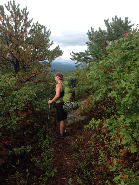
Scott along the Shawangunk Ridge in Wurtsboro Ridge State Forest
We parked outside a modest VFW hall under some shady trees, packed up our gear, and entered the woods where we spied a blue disk on a tree. This trail too was covered in green moss but with sodden leaves clinging to lichenized rocks. It had rained early that morning and the forest was still holding on to the precious moisture. Being mid-September, the leaves were just beginning to brighten, yellows lined with green veins and scarlet reds all the redder from the rain. However when the trail climbed here, we did not all that soon reach its ridge...

View from ridge in Wurtsboro Ridge State Forest 
We climbed up large boulders for what seemed like a long while before reaching the ridge where we walked along the rocky spine of the mountain. White Shawangunk slab rock sufficed for the trail that was lined with Scrub Oak (Quercus macrocarpa), low-bush Blueberry (Vaccinium spp.), Pitch Pine (Pinus rigida), and Sassafras (Sassafras albidum). For nearly 3 miles we walked with views to our left of the road that we had driven below to Wurtsboro. However the sun was setting quickly as we had gotten a late start...due to...ahem...some parking issues.

I hesitated to include our adventures in parking for the SRT because this is a trail I want to encourage others to hike...however, being that it is recently born as a long distance trail in a region that is traditionally that of day-long treks, the parking bugs are not yet all ironed out. We had initially tried to park one vehicle at the Mohonk Preserve, thinking we might end up here and if not, we could easily cab it to this destination from wherever we did...lemme just say I wish you could have seen the faces on those gatehouse attendees. I will never forget the look of horror as one employee exclaimed to her partner, mouth agape,

"They want to hike to NJ or something!!"

Our two pick-up trucks sat at the picturesque stone archway gurgling and whirring, while we stared at the empty parking lot and explained that yes, that was exactly what we intended to do. We were informed that there was no over-night parking but we would be welcome to park for the day after we each paid $21. They were so kind to let us turn around in that empty parking lot when we promptly exited and followed their directions down the hill to Spring Farm trailhead where they thought we might be able to do something so bizarre as parking through the night-time hours. We were also warned not to park alongside the road at any of the pull-offs as the authorities would surely impound the vehicle and charge us a hefty $1000 fine. My oh my...since when did a walk in the woods become so difficult? At Spring Farm trailhead we found a nearly empty lot but were greeted by a sign that stated there was no over-night parking and a box to slip some money into for daytime parking. Hmmm. We called the number on the sign and informed the person on the other end of our plans and asked if we might pay for several days parking as we would be hiking for 3 days back to our vehicle.

"Why would you want to do that?" A perplexed voice asked...they weren't referring to the paying part.

We followed the road to another entrance to the trail that we thought might be available for parking, but there was barely a pull-off in this residential area. Nonetheless we ended up driving back to where we had rented a room at a motel in New Paltz the night before and dropped one truck there, hoping it would go unnoticed for a few days. So this is why...our hike had started several hours later than expected that day. Stay tuned throughout this post and you'll get quite the punchline about...ahem...parking.

Anyway, back to our walk in the woods...

At camp near creek

We bedded down for the night along a slow-flowing creek and a stonewall in Wurtsboro Ridge State Forest. That night my luv dreamt of a green woman who shared her knowledge of Jewelweed (Impatiens spp.). In the morning we marveled at the Jewelweed that lined the rocky creek before us. Jewelweed is one of the best plants for cooling a Poison Ivy rash or itchy bubites. The woods seemed to welcome our presence.

Fire tower along SRT

That day we hiked...straight up...large white boulders that provided more of an obstacle course than stairs and soon crested a ridge of burned out forest. White and black skeletons of trees lined the way as well as a host of scrubby bushes, pines and rhodendrons. We could see that if only the clouds would clear we would have views to either side of us and when we reached a lookout tower we lamented the clouds all the more. We decided a snack was in order. During that break of almond butter and rice cakes, the heat of the day burned through the surrounding fog and we glimpsed the autumn mountains in the distance. Perfect. We climbed the well-maintained tower and got our view afterall. And this is the magic of the mountains...so often you find yourself in just the right place at the right time.

Scott taking in the view from firetower

Looking out at SRT ridge walk from firetower 
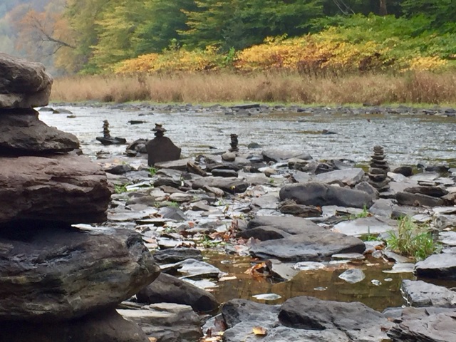
From here we walked along the ridge for roughly 3 miles, passing more large slabs of stone and carefully piled rock cairns that looked more the work of an artist than a hiker. The burned out woods continued, providing views as far as the eye could see as well as our path laid out before us over the continuing ridgeline. This was indeed the Shawangunk Ridge Trail. Although this forest was scorched we did have the pleasure of meeting tiny Sheep Laurel, a close relative to Mountain Laurel and classified as vulnerable in NY state...a lesson learned in why it pays to take your time. Hike too fast and you'll breeze by the subtle beauties along the way.

Scott walking the SRT though a burned-out ridge

Sheep Laurel (Kalmia angustifolia)
When we descended, we suddenly found ourselves in forest that had at one time been inhabited...I am guessing by cattle or sheep. White stonewalls still sturdy and strong squared plots throughout the woods and we walked alongside the stone wall that composed this ridge as we switchbacked our way down to a road. Here, our experience could not have been more different as we walked old route 52, which clearly had also been inhabited at one time...evidenced by a burned out trailer and an old stone foundations...but now was the dumping ground of present-day inhabitants. Improved Route 52 ran along the top of the embankment and it was evident that this was the mode of cheap and easy waste removal. I had visions of getting pegged in the head with a Big Gulp paper cup or pummeled with a broken microwave. Neither happened luckily and after a mile and a half we made our way back into the woods.

Stone walls along SRT
That evening after we set up camp, after a mere 7 miles, we were blessed with a nearby rushing creek, tiny waterfall, and a visiting owl. We sat in the pitch blackness and listened as the owl that surely perched in a tree just yards away shared his tales and we did our best to hoot back our own. He stayed for quite sometime and even called his lover to hoot by our tentside. Again, although the mountains had been challenging, we felt embraced by its life.

Enjoying South Gully waterside
On the last day we truly meandered, making a point to hike as leisurely as our minds would allow. We brunched creekside, hiked up and up and up along the deepening gorge of the South Gully and reveled in being in the woods for our third day. We soon arrived at the Sam's Point Preserve where we were welcomed by park employees. I had cell service for the first time in days and suddenly wished I didn't when I saw the slew of text messages and voicemails. The NY State Police had traced my truck that was parked at the VFW hall in Wurtsboro to my parents' address in Milford, PA and had sent a PA State officer to assess the situation at their home. My parents were in a frenzy, concerned that my truck had by now been impounded, and the warnings of the Mohonk House attendents resounded in my ears...although there had been no signage suggesting parking was not allowed at the VFW hall and it had been marked as an SRT parking area on the map. I promptly put down my pita and hummus and called the NY State Police barracks. When I finally got the officer that was handling the case, he was friendly and amiable, explaining,

"Oh no! You are fine to park there. We were alerted to the truck after someone noticed it had been sitting there for a couple days. We didn't know why someone would go hiking and not return. We were concerned that you were okay."

Again I asked myself...since when did a walk in the woods become so difficult? Now don't get me wrong I appreciate an officer's concern for my well-being, but if you thought I was indeed injured or lost in the woods, why would you look for me at my parent's house? This came on the heels of a terrorist bombing in NY days before...therefore I am guessing it had a whole lot more to do with being certain the truck was indeed registered to me. Nonetheless we decided we had better call that cab and get back to the other truck sitting at America's Best Value Inn.

We were overjoyed to find it untouched and unticketed upon arrival.


After our overnight advenures on the SRT from Wurtsboro to Sam's Point...we decided dayhiking might be the preferrable mode of travel along this trail. We have since returned to its southern terminus at High Point Monument, following it along an easy ridge walk and descending into the woods at Cedar Swamp (a glacial bog worthy of a blog all its own) and to the New York border.
A boardwalk through High Point State Park's Cedar Swamp
Most recently we also hopped on the SRT at the Basha Kill Wildlife Refuge which offers miles of hiking along the prisitine wetlands that comprise the refuge atop an old railroad bed. With boardwalks and carefully constructed overlooks along the way, this portion of the SRT proved far more beautiful than either of us had ever anticipated. The views were stunning, the chill wind invigorating, the leaves colorful, and birds many of which I could not name brought this marsh to life.


Marsh in Basha Kill Wildlife Refuge

Bird's nest in refuge
We were also stunned by how moderate the southern portion of the SRT proved to be. Turns out we had hopped on the trail in Wurtsboro right where the trail increased in difficulty. We had been lured in by its description of its offering the most astounding views in the Shawangunk region...and that it had...as well as some ego-bruising trail. However... I welcome a humbling from trail...a reminder to slowdown and show reverence for our natural world that we all to often stomp on through with our own agenda.
Scott walking along the Bashakill Kill Wildlife Refuge on the SRT
All in all we have hiked roughly 25 miles of the Shawangunk Ridge Trail...and I hope that we can manage to maintain our walking meditation on this trail...taking our time to navigate its boulder climbs, creep along its rough edges, pause at its pristine waters, gasp at its views, sit by its trees, listen to its inhabitants, and above all else, allow it to leave us breathless and wanting for more.

Friday, November 4, 2016

Trailing Turkey Tail


Turkey Tail (Trametes versicolor) 
Anyone who has been on one of my plant walks has heard me say, "My speciality is herbaceous and woody plants," after an attendee eagerly asks, "What mushrooms might we find today?" Mushrooms are a category in and of themselves, in fact a scientific class all their own: Fungi. My studies have had me trail many a green leafy, berry laden, crackling seeded, showy flowered plant...there are so many...but rarely does this leave the time for closer examination of the mysterious fungi world that aids the lives of these plants and provides yet another level of natural food and medicine for us. However with many of our green plants having already released their seeds to the soil until sprouting time in the spring, my senses are searching further, beneath the deepening layers of leaves now blanketing the trail.

Turkey Tail (Trametes versicolor) shelves forming a rosette shape
Yesterday, my love and I ventured to Delaware State Forest for a walk along an unnamed trail. We marveled at the now-bright red berries drooping from beneath the nearly whorled leaves of Wintergreen (Gaultheria procumbens) and enjoyed spotting the fuzzy leaves of Trailing Arbutus (Epigaea repens), we even spotted a few lone still-yellow flowered Goldenrod (Solidago spp.)...but nothing compared to the concentric-circled scallops of the Turkey Tail (Trametes versicolor) mushrooms that clustered rose-like around small stumps along the trail. These woods are made up largely of Black and Yellow Birch (Betula lenta and B. alleghiensis, White Pine (Pinus strobus), Eastern Hemlock (Tsuga canadensis), and a variety of Maple and Oaks (Acer spp. and Quercus spp.)...however it seemed that Turkey Tail prefered the Black Birch. I can't blame 'em, that Wintergreen flavored bark is somethin' else. And if you look closely here, it seems the bear may take a liking to the Turkey Tail as well, either that or this scat was just happenstance.

Turkey Tail (Trametes versicolor) beside bear scat
Turkey Tail (Trametes versicolor)is a polypore mushroom, meaning that it bears contains on its underside, as opposed to say gills or teeth. It forms in layered shelves on dead hardwood and rarely, the dead wood of conifers. It's scientific name is evidence of its versatile color scheme, ranging from shades of brown to blue to green (when aged and sharing its surface with an algal partner). Its surface will be conspicuously velvety to the touch. This mushroom has been valued as a medicinal in Chinese medicine dating back to the 15th century, useful in boosting the immune system when comprised. It's evidence of efficacy is so strong that Bastry University is presently funding a $5 million research project to find out just what makes Turkey Tail tick and how it could possibly build the immune systems of those undergoing chemotherapy for breast and lung cancers. Herbalists today use it to fight colds and flus and sip it as a preventative during the winter when these ailments are most likely to strike.

Turkey Tail (Trametes veriscolor) on Black Birch (Betula lenta) bark
So I returned today to harvest the only turkey I will be partaking of this Thanksgiving. I went for a short jog carrying on my bag a small daypack with a large ziploc and sharp knife to aid in removing the leathery mushrooms from their barky hosts. After about a mile, I spotted the multi-colored rosettes and so slowed my step to take a seat and spend some time with this community of mushrooms before harvesting. As I did, I was struck by how alive this forest now sounded that moments ago had seemed primed for slumber. Startled, I scanned the forest for sign of deer rifling through or perhaps even a bear lumbering towards me from afar. It took some minutes for my eyes to catch up with my ears and, gradually, I spotted the numerous chipmunks scurrying over fallen trees, the squirrels darting to and fro over and under the leaf litter, and even the whooshing of a bird's wings through the few trees overhead that persisted in holding tight to their papery leaves. All this activity had sprung from just these small creatures...I had needed only to pause long enough to notice them. An act that I all too often fail to do...pause.

Witch Hazel blossoms (Hamamelis virginiana)

But with the light growing ever closer to the golden hue of the Witch Hazel (Hamamelis virginiana) blossoms nearby, if I was going to get my Turkey Tail before I too found myself nesting in the woods for the night, I had better get to work. Using my small knife, I sliced at the scallops' bases, carefully selecting the most fresh looking, leaving those that had already been sampled by the resident insects as well a good number to guarantee that this community would be flourishing when I returned later in the season for another harvest.  

If you do go venturing for your own harvest, bear in mind that there are look-a-likes, such as False Turkey Tail (Stereum ostrea), which is also capable of hosting a variety of colors and a similar velvety texture. The best way to discern these two is to flip over your potential Turkey Tail. True Turkey Tail (Trametes versicolor) will be pale in color and should bear many tiny pores, evident to the naked eye. False Turkey Tail will mimic the colors of its upper surface or be simply tan to brown in color bearing a smooth or bumpy surface. I have found no reports of False Turkey Tail being poisonous...nor have I found any history of usage. There are also a number of species of true Turkey Tail (Trametes spp.) that will exhibit slightly different textures atop its surface and lesser pores on underside of cap. These may be more or less medicinal, but all evidence points to the particular species (Trametes versicolor) discussed here. Therefore, surely exercise caution when harvesting Turkey Tail or any mushroom for that matter and be certain that you have your desired mushroom in hand before consuming.


Tuesday, November 1, 2016

Pennsylvania- it's WILD out here!


Pennsylvania Wilds
Once when I was 19 years old, I drove across the state, packed in a car with 4 friends to see Rusted Root in Pittsburgh...I remember a whole lot of barns, rolling hills, fields of crops and of course the occasional Amish wagon being pulled by horses alongside the highway. This was more or less my western exploration of a state I was born and raised in. In fact, besides long-distance hiking the narrow corridor of the Appalachian Trail (that consisted largely of rocks), I had never much explored Pennsylvania outside my northeastern corner. That is until I received an invitation to speak at the Keystone Trails Association's annual gathering in Emlenton, PA. Emlenton sits on the edge of the Allegheny National Forest, just some miles northwest of Pittsburgh and just south of where I began my journey on the FLT in NY. My love also had a couple of concerts to play out in this neck of the woods. So given that we would be driving over four hours to the other side of the state, we thought we may as well take our time and explore this place that we call home.

It proved to be far more than rocks and Amish.

Because we took a more northerly route, we traveled through the round-top mountains of Pennsylvania. There simply isn't that much room for rolling farmfields. Those that we did see, were planted against the sides of steep hills, mostly good for grazing cows. We pulled off at a little town called Brookville to stretch our legs and marveled at how it made use of the strip of flat land in between the mountains for its mainstreet and all of its side streets seemed to go straight up or straight down....a good number of which were cobblestone. The storefronts lining the main street were two- and three-story, flat-faced, each sitting flush against the next, like a town out of the old West. Most all of the practical stores were dusty and shuttered, whereas those that were open were filled with trinkets from the past...antique store after consignment shop. The next exit up from Brookville was home to a Wal-Mart and all the accompanying big-box stores. No more need for the family owned businesses. However, we did take the time to peruse one of these store-front time capsules, and found a number of fellow patrons therein, all clad in camo, including the shopowner. Oh...there was a functioning taxidermy shop in town...that's one thing Wal-Mart hasn't figured out yet.
A Botanical Hike on the Finger Lakes Trail presentation at the Keystone Trails Association annual gathering
Once in Emlenton, we stayed at a lovely camp tucked into the hills and enjoyed a weekend of meeting folks who love hiking in Pennsylvania. The Keystone Trails Association's annual gathering brings together people from the numerous hiking clubs within the state as well as Pennsylvania chapters of organizations such as the Appalachian Trail Conservancy and The North Country Trail Association. We even got to hop on the North Country Trail for a group hike. This trail led us through a boulder strewn woods which held remnants of oil drilling and natural gas transport. Throughout the weekend I had the opportunity to chat with a good many of the attendees and what I appreciated most was how present each one was and the wonder with which they hiked when tramping down the trail. This was not a group hiking for the motivation of patches or awards or to impress...rather they hiked to be impressed by their natural surroundings. The experience was the award in and of itself.

Relaxed and renewed from our time at the conference we headed for the Wilds. This is a 2 million acre patch of mountainous land in the center of Pennsylvania that is home to wild elk, the Pennsylvania Grand Canyon, industrial megaliths of time gone by, and pristine woods that at this time of year are a radiant collage of orange, yellow, scarlet red, bronzes and browns.

Kinzua Bridge Skywalk

View of destroyed Kinzua bridge
Our first stop was at the Kinzua Railroad bridge located just outside the town of Mt. Jewett. This industrial jewel was at one time the tallest and longest railroad bridge in the world. Built in just 94 days in 1882, it reached 300 feet into the air and spanned over 2000 feet across a gorge from mountaintop to mountaintop. In 2003 a tornado ripped through the valley, leaving a scarce 600 feet of bridge that has now been converted into a walkway and at its base a maze of trails. It was still a knee-shaking wonder to walk to it's edge, gazing out at the sea of trees surrounding us and the wreckage of iron and steel below. Glass plates were even installed so to give the feeling of standing on air. Although the visitors on this beautiful weekend day were numerous, the scenery prevailed.

A-frame outside Wellsboro
We spent two nights in this tiny A-frame just outside the town of Wellsboro. It was equipped with all the necessecities of heat, electricity, a bed, stovetop, bathroom, running water and none of the frivolous extras such as wifi, more than 13 channels on the 12-inch TV, or cell service. Perfect for removing one's self from the interweb and immersing one's self in the wilds.

Pennsylvania Grand Canyon
The next day we traversed both the east and west rims of the Pennsylvania Grand Canyon. In Leonard Harrison State Park we hiked the Turkey Path which parallels a series of cascades and travels 1000 feet down to Pine Creek which snakes along the canyon floor.  On the western side in Colton State Park we trekked the West Rim Trail which meanders along its western edge, knocking out 5 of its 30 miles.

Pine Creek falls

Pine Creek with rock cairns

As for the plant life of this gorge, I was surprised to see many plants that I associate with either more northerly mountains of New York or taller mountains of North Carolina, such as Virginia Waterleaf (Hydrophyllum virginianum), Foam Flower (Tiarella cordifolia), Wild Aniseroot (Osmorhiza spp.), and Wild Ginger (Asarum spp.). The Eastern Hemlock (Tsuga canadensis) were also so healthy here that we barely recognized them. We are used to seeing Eastern Hemlocks wrought by the effects of the Wooly Adelgid, with needles of a dusky green and bare branches. But here their boughs were heavy with white banded needles that shown vibrant green.

Virginia Waterleaf (Hydrophyllum virginianum)

Wild Ginger (Asarum spp.)
Driving home, we largely took route 6, weaving our way through tiny town after tiny town. What I was most struck by here and throughout the mountains of PA, were the equally tiny houses nestled in these hills. I saw nary a McMansion, the largest homes being instead old farmhouses. Some of these homes were ramshackle, some cabins that had clearly been part of a camp of one kind or another, and many simply small, purposely quaint. Gas stations were few and far between and when we did stop for fuel, locals held doors and cashiers seemed genuinely glad to make small talk. These seemed to be people who appreciated their surroundings more than their belongings and as a result had the time and presence of mind to be kind to strangers...who mind you probably looked like "city folk"...and this is usually the last thing I ascribe to myself. But it's all relative. Our travels also shed some light on the culture of our little town that we presently live in, Lackawaxen... just off this very same route 6.

When we finally crested the mountain for Scranton and plunged into the spiderweb of interstates, big box stores of every kind, flurry of cars and changing lights, and stopped at a Starbucks for some coffee, our senses felt overwhelmed and agitated. Indeed its all relative, and once you've unplugged it's all the harder to plug back in. Good to know that the Wilds are not far away and maybe... a whole lot closer than I thought.

Pennsylvania Grand Canyon
Thank you to the Keystone Trail Association for the opportunity to share my story with you and thank you to all the hikers who attended! Hope to see you on the trail!