Friday, September 22, 2017

Over 200 Miles: The Shawangunks and Catskill High Peaks!

Scott and me on Slide Mountain - the highest peak in the Catskills!
What an incredible week it has been it has been along this astoundingly beautiful and challenging trail. We are presently just over 200 miles along in our journey, having traversed the Shawangunks and most recently the Southern Catskills.

Saying hi to John Dezzutti
But before I get started on the hike details, I would like to introduce you to John Dezzutti. While hiking the long hill out of Wurtsboro, packs heavy with resupply, this friendly face went zipping by in his car honking. We waved and walked on…when just up ahead we saw that he had driven by again and turned around. He hopped from his car and crossed the busy road just to wish us good luck on our adventure. He has been following the blog and just so happened to be driving through the area without even knowing we were in Wurtsboro. He offered us treats and cold drinks but we were already laden. He and his girlfriend are working away at a 41 mile trail in Connecticut. It was so nice to meet a fellow hiker and a blog reader! Thank you for introducing yourself!

The Shawangunks proved to be just as challenging as we remembered them to be. We had section-hiked the SRT from just outside of Wurtsboro to Sam’s Point last year over the course of 3 days. However this time, we did nearly all the same number miles in our first day out of town. The Shawangunk Ridge regularly experiences fires, it is essentially a part of its natural cycle. However nearly a century ago, the local berry pickers would light these mountain tops aflame because they found that it increased yield.

trail along Shawangunk ridge 
As a result, the vegetation atop these ridges is stubby and scratchy. The ground is a thick layer of pine needles and white sandy soil interspersed with white slabs of Shawangunk rock. With Autumn quickly approaching the plants that do call this place home, such as the High and Low-bush Blueberry, Wintergreen, and Sassafras were aflame with color.

Blueberry leaves (Vaccinium)

Sassafras leaves (Sassafras albidum)

Wintergreen (Gaultheria procumbens)
And with all this low vegetation, the views are breath-taking and the atmosphere is other-worldly. Both days that we walked the Shawangunk Ridge from Wurtsboro to Sam’s Point to Verkerdeerkill Falls to High Point and finally down along the Carriage Smiley Trail were blazing hot and nearly without a breeze. The views which you can see below were sweeping and to walk bare rock cliffs, sometimes just along the edge, with the multitude of changing leaves was an experience in and of itself. But, my God, we thought at times we were in the southwest!

Walk along ridge to High Point

Atop High Point in Minnewaska State Park Preserve

And we were not alone in the Shawangunks!

We again had the joy of Star Left coming to join us for a night down just outside of Minnewaska and for some sweet miles again from Sam’s Point to Verkerdeerkill Falls. Her weekly visits have been a highlight and we were glad that we were in such a special place when she was free to come join! Thank you Star Left! We are looking forward to next time!

Starleft an me at Sam's Point
We also met a group of sectioners along the Long Path! Meet Victoria, Ben, Karen, and Jeff! They are steadily hiking this trail piece by piece and predict they will have it complete in 2 years. It was so fun chatting with y'all...see you down the trail!

Meeting Victoria, Ben, Karen and Jeff in Roosa Gap along SRT/LP
 Once we descended from the Shawangunks, we had a day of long roadwalking through Warwarsing and Riggsville. However these roads were sometimes dirt leading down green country lanes and at other times leading us uphill of course but beside quaint farmland that had obviously been farmed for centuries, we even got to see a herd of cattle with the little ones frolicking about. We spied centuries old farmhouses and humble cottages, each one more intriguing than the next.

roadwalk through Riggsville

Crossing Rondout Creek in Warwarsing
We entered the Catskills on easy terrain in the Sundown Wild Forest. Here many of the trees were toppled due to the wet soil which truly gave the place an untouched feel. We lunched at Vernooykill Falls and enjoyed 9 miles of cruising through easy terrain before we hit the real stuff: the high peaks of the Catskills.

Vernooykill Falls
Our epic trek into the peaks of the Catskills began passing the Finger Lakes Trail eastern terminus sign on our way to Peekamoose. This was rather surreal! We took some pics and prepared for the climb. We saw on the map that this climb would be 2500 feet over the course of 3 miles, so we decided that we would tack it onto the end of a day and only hike about half way up. We have affectionately dubbed Peekamoose, Peekaboo instead, because it comes as a surprise!

Finger Lakes Trail Eastern terminus - this is where I finished my two month trek two years ago!
On our way up Peekamoose we also had our first glimpse of the boreal forest that has now persisted throughout these higher peaks. The forest is filled with sweet candy-like aroma of the Balsam Fir and Mountain Ash berries hang heavy and ripe from the trees overhead sometimes even littering the trail. The Wood Sorrel leaves are large and heart-shaped with purple undersides in the vibrantly green moss underfoot. Trail markers are nailed to peeling Paper Birches and Yellow Birches reach their roots long and snaking down the sides of large boulders. Hobblebush with its broad now darkening purple leaves brush at your elbows. It is a magical place.

White Birch (Betula papyrifera)

Hobblebush (Viburnum lantanoides)
After Peekamoose came Slide Mountain – the highest peak in the Catskills (4180 feet). The going up was easy and the views were so epic it almost made us weak in the knees but the coming down was far more difficult. We saw in the guide that there would be ladders we had to climb down rock faces but those 20 foot rock faces without the ladders were far harder. We ended up literally throwing our packs down to each other and using our whole bodies.

Scott descending Slide Mountain

one of the slick rock faces we had to descend from Slide Mountain

view while ascending Slide Mountain
On the next day we summited Cornell, Wittenberg, Cross Mountain, Mount Pleasant, and Romer Mountain. We thought five peaks in a day over 12 miles was pretty good!

view of Ashokan Reservoir from Wittenberg Mountain
We are now looking at a 40 mile section of trail with just two road crossings and a hike along...the Devil's Path, reportedly the most rugged hiking trail in NY! Wifi and cell service will likely be slim through here, if any at all, but we will do our best to keep you posted! Central Catskills here we come!

For those of you who are the botanical lovers...I have been posting regularly on our facebook pages the highlighted plants of the trail. It has proven too difficult to copy and paste them to the blog due to tech and lack of wifi. Please check our the facebook pages to see these! www.facebook.com/thebotanicalhiker  and  www.facebook.com/hikelocal

Friday, September 15, 2017

Long Path: Over 100 miles!

Scott alongside boulder in Harriman State Park

Since my last post we have trekked over 130 miles along the Long Path from 175th Street in Manhattan. At the end of last week we took our first steps into one of our favorite parks in the region, Harriman State Park. I first fell in love with this special place while hiking the Applachian Trail, it was also the first place that I ever set eyes on the Long Path...


Intersection with Appalachian Trail

On my first long hike along the Appalachian Trail, I remember coming to this very intersection and seeing this sign for the Long Path. I looked at my miles with nearly 800 miles still to go and thought I am on the longest of paths! But I couldn't help but be intrigued by this other long trail that apparantly ran on nearly 300 miles in the other direction. Since that hike Scott and I have returned multiple times to Harriman for day hikes along both the AT and Long Path but never had enough to time to really explore. Well with three days through Harriman...this time...we really soaked it up.

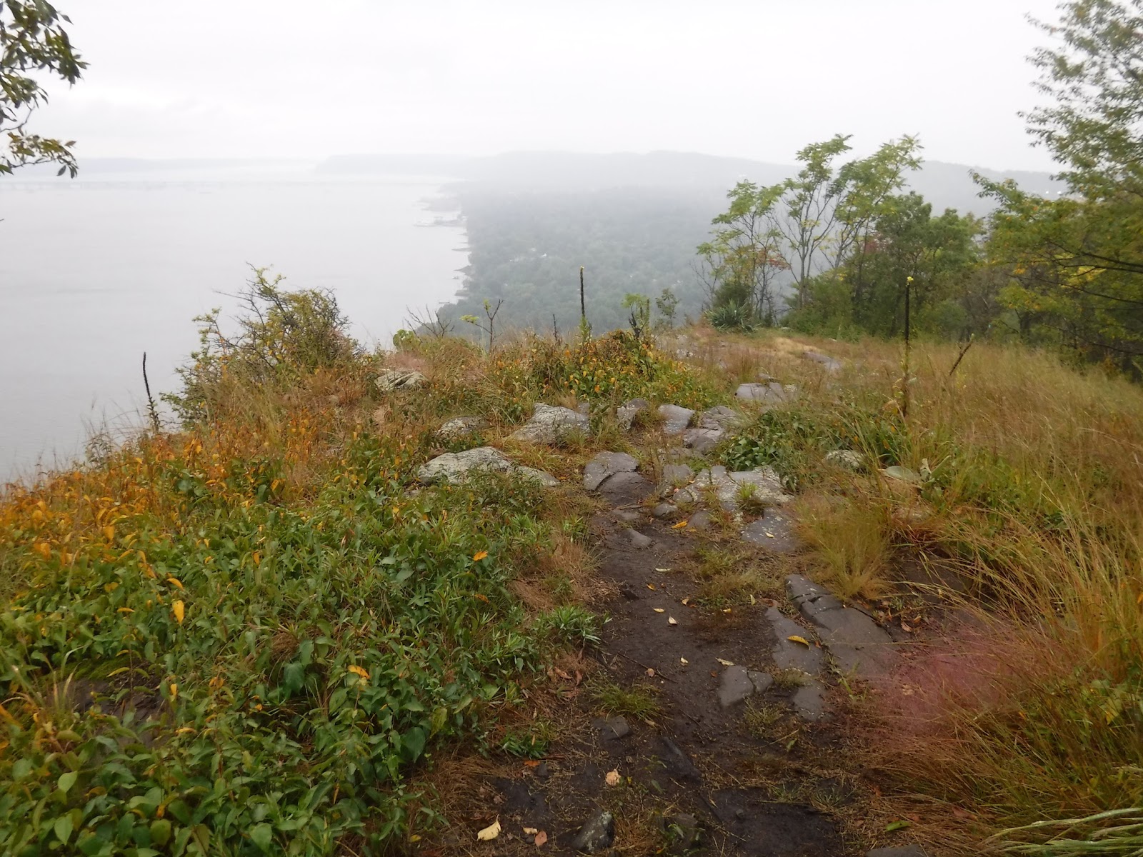
Scott climbing boulder in Harriman

Harriman is known for its grassy trails strewn with glacier rolled boulders. The trails rolls on over many a hill and over rocky topped mountains. The woods are typically open allowing lots of light to pour through the canopy and affording gorgeous views from the cliffs. It is here that the first miles of the Long Path were also laid - so it felt pretty amazing to be walking a bit of Long Path history. We camped throughout this section but the shelters are also a piece of history, many having been built from stone in the 1930's.

Big Hill Shelter

There is even a memorial to Raymond Torrey, the man who first began scouting the Long Path route from the George Washington Bridge through the Catskills and who would publish articles weekly in the New York Times promoting each section he mapped.

Torrey Memorial - Harriman State Park

Speaking of NYC...we became suddenly disoriented and terrified when we came across this trail marker...had we gone through a time warp??

Harriman's Times Square

We decided we preferred this Times Square to that of NYC, especially considering there was not another soul around and we were amidst a mountaintop garden of Goldenrod, Sweet Fern, and Pine. 

Hiking with fellow FLT hiker buddy, Star Left

While hiking our last day in Harriman, we also had the incredible company of a trail compadre, Star Left. For those of you who followed my blog along the Finger Lakes Trail, you will remember that Star Left was one of only two long distance hikers I met while thru-hiking the Finger Lakes Trail over the course of 2 months. This badass woman ended up hiking 700 miles from Niagara Falls south along the Finger Lakes Trail and then the Great Eastern Trail. When she heard that I would be thru-hiking this trail, she offered her maps and assistance along the trail and best of all, her companionship. Star Left met us during our most rugged day through Harriman on which the three of us summited four steep peaks. She camped with us and brightened our night as well. She brought fuel and water to boot! Thank you, Star Left! 

Schunemunk Ridge

Scott atop the Schunemunk Ridge

After Harriman, we descended to Estrada Road and into Central Valley where we took a lunchtime detour to Danny's Deli. Anyone who may be hiking this trail through this area should stop into this lil deli that Danny has owned for 20 years - he makes a mean egg salad sandwich and was more than accommodating to all of our hiking needs. Thank you, Danny! And thank you to George of Estrada Rd who filled our water bottles and made the recommendation! This was just the boost we needed to climb High Knob in Schunemunk State Park and climb even higher onto the Schunemunk Ridge. Scarlet Mountain Ash berries lined the cliffsides and the views were tremendous. We could even see the Catskills from this rock slab ridge, pointed and layered in the distance. 

Atop Schunemunk Ridge

What we did not know on this evening, was that we had unknowingly turned the wrong direction onto the yellow-blazed Jessup Trail that the Long Path is co-aligned with along the ridgetop. It also runs in the entirely other direction down the opposite side of the ridge. After a night of sleeping with the coyotes - which was alarming when we realized they were on the boulder just behind our tent but also pretty darn cool - we hiked several more miles the wrong direction over the most challenging portion of trail that we had hiked yet out here. We realized about 3.5 miles later that we had gone the wrong direction. The detour was by all means rewarding, more picturesque than the easy miles of the Long Path going the other direction on the ridge...but we would have happily save those miles for a day hike. 

Heritage Rail Trail

As a result, we hit the lil town of Chester much later than planned for an evening of reprieve but at least the miles were easy the next day. Beginning in Monroe and traveling through to Goshen we would have this easy path to hike: the Heritage Rail Trail, 11 miles of graded and mostly paved walkway. And again we were graced with friendship! Our dear friend, Alex from Asheville, happened to be driving down Route 84 coming from visiting family in Connecticut and en route to visit more family in Pennsylvania. Lucky for us, she thought it would be a grand idea to drop in on us on the trail and join us for a stretch! Asheville is my other home and so to have a lil piece of my Asheville fam join us on this trail made my heart smile. Alex also assisted us with 4 miles of slackpacking along the trail. What a treat! Thank you Alex!! 

At Historic Chester train station with our dear friend, Alex Krug

After these gloriously easy miles with a stop-off at Amore's Pizzeria in Goshen - highly recommended! - we spent the night at a stealth campsite with a porcupine and had another day of walking the pavement. This time for 15 miles through the towns of North Hampton and Waywayanda. Normally I think of road miles as easy ones, but many of these were straight uphill. However there were still some interesting finds such as the roadside wild edibles and a free library!

Free library along Long Path road walk

Chicory (Cichorium intybus)

We spent that night beside a beautiful pond on DEC land and then had another stretch of easy walking along the abandoned Erie railway as well as the power-lines. Along this portion of trail we crossed another special trail: the Shawangunk Ridge Trail, a 71 mile stretch of trail that we began section hiking last year. 

Scott and I at junction for Shawangunk Ridge Trail

That afternoon in the town of Otisville, we had a special visit from my mother. We devoured lunch at Nick's Pizza in town and enjoyed several hours of just sitting and chatting. She was the highlight of our day! And she brought some helpful resupply items like heavy duty tinfoil and water! Thank you, Mama!

Pond along DEC land

Scott walking trail under powerlines

Mullein rosette (Verbascum thapsus)

After a lovely visit with Mom, we then had more trail magic...Andy Garrison, chair of the Long Path and a friend as well! We had no sooner been dropped off back at the trailhead and walked a few yards across the road to begin our climb of Gobbler's Knob when a pickup truck pulled over. It was Andy with a load of trail maintenance gear in the back of his truck. He had been busy cleaning up the trail in preparation for the big Shawangunk Ridge Trail Race that will be happening this weekend. We had a nice long visit there on the corner of Route 61 and 211. Another bright spot in the day. Thank you Andy for all your help so far in helping us to plan our hike and in all the work you do for the trail!

A chance meeting with our friend and chair of the Long Path, Andy Garrison

And so we are in the Shawangunks!! Having started the day with a hike along the beautiful Basha Kill Wildlife Refuge. This large swath of marshland is rich with bird, reptile, and amphibian life. This portion of the trail is also along an old railroad bed and so is nicely graded and with the White and Gray Birch as well as Oaks and Maples that line the trail corridor you feel as if you are walking through a picturesque green tunnel. We had also explored part of this refuge last year when section-hiking the Shawangunk Ridge Trail, so we knew to expect beauty but I believe it was even more beautiful than before!

Basha Kill trail

Baby snapper turtle (we think?)

Jewelweed (Impatiens capensis)

View of Basha Kill

 Shawangunk Mountains here we come!  Stay tuned for the next post!


Sunday, September 10, 2017

The Long Path: High Adventure along the Hudson!

Scott and I at the southern terminus of the Long Path: the 175th Street Subway Station

Our first miles have been breath-taking in more ways than one! We are presently en route to Chester, NY having covered the Palisades and the Hudson Highlands, however for the sake of brevity...well kind of...I will catch you up on the first four days.

Firstly, I must say navigating parking on Labor Day in Fort Lee so that we could begin our hike at the 175th Street subway station and walk across the Hudson River on the George Washington Bridge was a challenge in and of itself. Thank you Mom and Dad for braving the city driving! But it was well worth it - the bridge was surprisingly majestic, with the American flag hanging from its archway and my parents walking hand and hand before Scott and I accompanying us for our first few miles along this 400 mile trail through New York. Even with the bicyclists zipping by, the runners weaving their way between us, and the steady stream of cars whizzing down its corridor, it couldn't dampen the magic of the moment...in fact I believe it enhanced it. This trail was surely created as a respite from the harried experience of urban living...and never before had I begun a trail is such a setting...it was perfect. The more I have hiked long distance trails the more I have come to realize that I appreciate those that blend civilization with wilderness, people with nature. I see no reason why we have to see ourselves as separate when we are obviously intertwined.

Mom and Dad guiding us down the George Washington Bridge to the start of the trail in Manhattan

The Palisades Park proved to be far more grand in its beauty than we had presumed as well. I have always thought of the Palisades as the interstate and never as an actual park. Sure, the park's corridor is slim but it is lined with incredible vista after incredible vista and all along a level walking trail...well for about the first half until you start to hit the rock steps. The historical sites along the trail were intriguing and sometimes masterful and we couldn't help but marvel at the number of old growth trees along the way...how had they survived the quarrying and logging? This section was a perfect way to start a long trek, nice and easy and with lots of rewards. We walked this park for roughly the first two days and covered about 24 miles.

Hugging a Black Poplar (Populus nigra) along the Palisades - how old do you think this tree may be?

View of George Washington Bridge (GWB) from along the Palisades 

early evening view along the Palisades with Hudson River and Yonkers in the distance

Scott playing King of the Castle at the Monument to the Women's Federation who were instrumental in  forever protecting the Palisades from quarrymen (let's not consider the contradiction here) 

Scott descending large stone slabs in Palisades Park

We dropped into the town of Piermont for an icy cup of chilled coffee at Bunbury's Coffee and after many ups and downs through the rocky hillsides in high temps (summer had suddenly returned!) stumbled into Nyack at about 8:00 pm and treated ourselves to a rather glamorous hotel - but no more expensive that your average Day's Inn - called the Time. We had no idea the atmosphere we would encounter when we made the reservation over the phone! This place had oriental rugs embroidered with Day of the Dead skulls, faux white fur sofas, and the entire place outfitted with Alexa - that app that lets you make lights turn on, gadgets start working, and make phonecalls using only your voice like in the Jetsons. Let's just say it took us 5 minutes to figure out how to turn on our bedroom lights. It was a far cry from the trail but a welcome haven from the rainstorm that would be rolling in that night.

Hanging out at the post Time Hotel in Nyack

On our third day, my father came to meet us for lunch and to switch out some gear. Turns out we didn't need that cold-weather sleeping bag after all. Thank you, Dad!! That helped us drop some weight and lifted our spirits on a day where we would be walking for the afternoon in the rain. Although this day was short in mileage - about 6 miles total - we summited Hook Mountain which was all the more stunning in the fog and mist. We remarked at not only the native Prickly Pear that we found in large communities at its summit but also the candelabras of Mullein that stood on its peak - again a juxtaposition of native and non-native, wild and civilized.


View from Hook Mountain with silhouttes of Mullein stalks

View from Hook Mountain

Prickly Pear (Opuntia humifusa)

We also had the pleasure of meeting a unique soul named Lisa Snyder who hikes the trail daily with her menagerie of lovable dogs. We stopped and chatted and she informed us that she has walked this trail daily for 7 years and never met someone doing what we are doing. Well after learning what she did, we informed her that we had never met someone who did quite what she did - dedicating her life to the bettering of the lives of dogs. Check out her non-profit page on Facebook at www.Facebook.com/Free-Dog. It was a pleasure meeting you, Lisa! Thank you for all that you do! Also thank you to Knickerbocker Engine Company near Rockland County Park for bringing us in to fill up our water bottles!

Scott, Lisa, and myself along the Long Path

On our fourth day, we hiked a solid 13 miles beginning late and leisurely enjoying the rolling hills of Rockland State Park and summitting High Tor...the highest mountain along the Palisades. The climb was rocky and the views were tremendous, giving us a view far away down the Hudson from where we had come, the towns of Mount Ivy and Haverstraw below to which we would descend and the green mountains of Harriman State Park in the distance.  

View from summit of High Tor

From summit of High Tor

We were happy to descend from here to a number of miles on forest road and then along a grassy cliff filled with Cedars and Hickorys and grapevines, we felt as if we were walking along a mountain-top garden. Along the way we even caught a glimpse of the Manhattan skyline now foggy and almost imperceptible except for the rectangular outline of a handful of builidings...we were a long way from the George Washington Bridge!

view of Manhattan skyline from cliff above Mount Ivy

Hickory nut
Finally descending to the road, Rt. 202 in Mt. Ivy, we were pleased to see a host of stores and restaurants - supermarket, pharmacy, liquor store, every kind of restaurant (including an Indian one we had visited nearly a year before and we didn't even know that we were in the same town), and a pizza place that had the most amazing eggplant rolls ever. Thank you to the kind pharmacist in the pharmacy on the corner of Rt. 202 who helped us assess our fire ant bites...we had no idea the damage these critters could inflict...think tiny boils all over...we were definitely in need of some first aid.  However due to our lengthy stop, we found ourselves literally hiking into the darkness at about 7:30 pm for what we thought would be an easy 1.5 mile walk into the woods to camp for the night. Turns out not too many people hike this portion of the trail. It was the most overgrown with weeds that we had seen and was really not one to have taken on in the dark when the trail was really nothing but a jumble of ankle twisting rocks. We walked a narrow strip of land just below the Palisades Parkway on one side and a chain-link fence on the other. We searched for blazes in the dark with our faint headlamps and even crossed a narrow stone walkway over what looked like a very deep and dirty stream...not one that you would want to fall into. After this fun we ascended  Cheesecote Mountain and finally gave up just before the top somewhere in the woods at about 9:30. Note to self...this portion of trail best reserved for hiking in the daylight.

Scott along a ridge in Harriman State Park
The next morning we entered into Harriman State Park...one of our favorite in the region...this post soon to come!